Information
MRO is located at an altitude of 3930’ (1198 m), a longitude of 120.7278 degrees West, and a latitude of +46.9528 degrees.
The 30” (0.76 m) Boller and Chivens telescope is equipped with a 6-position filter wheel and a CCD camera with a field of view of 8 x 8 arcminutes and a plate scale (using the default 2 x 2 binning) of 0.93 “/pixel.
The telescope is a Ritchey-Chretian design with an original focal ratio of f/13.5. Achromatic focal reducing optics mounted approximately one inch behind the Cassegrain focus change the effective focal ratio to f/6.7. The focal reducing optics are optimized for the wavelength range of 3650-8520 Å.
The observatory is open from May through November, with the UW’s Astro 481 class taking much of the time from late June through the middle of August. Approved student groups can propose for observing time by getting in touch with Oliver Fraser via email: ojf@uw.edu.
Safety Checklist
-
First Aid kits are located in the kitchen, on the telescope pier, and in the safety kit. The kitchen kit includes small amounts of over-the-counter pain medication, eye wash, and even a snake bite kit. The medicine cabinets in each bathroom have other supplies you may need.
-
Keep the gate locked so animals don’t get trapped within the fence, and so you can choose who visits you.
- Summer is wildfire season, and it’s not unusual to see smoke. If you see smoke nearby you should look up the fire’s name/location and any road closure or evacuation information. If you cannot find any information about the fire, it may be new, call 911 to report it.
-
Information on nearby fires is typically posted on Facebook by the Kittitas County Sheriff or Yakima Valley Emergency Management. You can also check the Map of Fire site or the WA Dept. of Fish & Wildlife Wildfire Info page.
-
If you cannot find any information at those links, the DNR Fire Dashboard displays both NASA/USFS FIRMS hotspot data and will reveal the names of known fires.
-
Large fires are tracked on a map at Inciweb and by name at NWCC).
-
Smoke from distant fires isn’t a safety issue, but does affect observing. You can check the Real-time Air Quality Index (and forecast!) for Ellensburg.
-
- In case of any accident, report it to the observatory staff.
Things to Do
MRO has a full kitchen, a grill, games, books, movies, a fantastic record collection, and fast internet. You can bake brownies in the 8”x8” pan, practice your origami, or catch up on your summer reading list. Hiking in the surrounding area requires hardy shoes, a buddy, and bright clothing (hunting season is late summer, but you should always be obvious to other animals, including humans!). Many of the best features of the observatory are thanks to our undergraduate users, so if something looks like it needs attention, and it’s within your skill level, dive in!
Directions
MRO is approximately 9 miles West-Southwest of Ellensburg, WA. It’s about 3 hours from Seattle to the doorway of MRO, but please note that the last 15 miles of the road are unpaved, and have potentially dangerous turns and road hazards. Please drive slowly and carefully.
The map below shows many useful landmarks mentioned in the directions below. You may wish to supplement these directions with a better map, but do not depend on online resources as you are driving. Most people find that their phones do not have service on many parts of the route, and driving directions do not replace knowledge of the landmarks below.
-
OpenStreetMap seems to have the best road map of the area.
-
You can also see the route on this Google Map.
-
The official road map of the area is the “Green Dot” map for the Wenus Wildlife Area.
To get to the observatory from Seattle you start by taking I-90 East to the Canyon Road exit, which is the last Ellensburg exit along I-90. At the bottom of the exit ramp you turn right on Canyon Road and head back towards Ellensburg. Umptanum Road is half a mile from the Canyon Road exit, marked by the two-story subway. Turn left onto Umptanum Road.
After a mile and a half on Umptanum road, you will pass Dammon School on your right, and soon after the road will lead you up the Shushuskin Canyon. At the top of this canyon and the road will turn into an unpaved dirt road. From this point, you will travel 10.0 miles before you get to the Observatory Road. All the following distances are measured from this point.
-
Watch out for the sharp, descending turn at 3.3 miles.
-
About 4.5 miles in the road often gets rough as you descend toward the Umptanum Falls trailhead. There’s a gravel parking lot with a 30 minute hike into a really lovely waterfall tucked in amongst the hills. Well worth the detour!
At 10.0 miles turn right onto Observatory road. You will know you are close to the intersection when you pass a large house with a green roof at 9.6 miles. You will descend a short hill and find the a wood and wire gate on the right that you may need to open. Be sure to leave the gate in the exact same state as you found it.
Once on Observatory Road, turn right at all forks until MRO’s driveway. You will pass:
-
A cattle grate at 11.3 miles.
-
An intersection at 12.3 miles with a road referred to as Mudflat Road on the map below or Manastash Ridge Road on online maps. As usual, turn right.
-
Umtanum Creek at 12.5 miles.
-
The last right turn at 14.2 miles.
At 14.7 miles you have just passed a big yellow DNR gate and will be almost to the top of the Manastash Ridge when you’ll reach a fork in the road. The left leg of this fork is the observatory’s “driveway”. Take the left.
Congratulations! You’ve made it to MRO – enjoy your stay!!
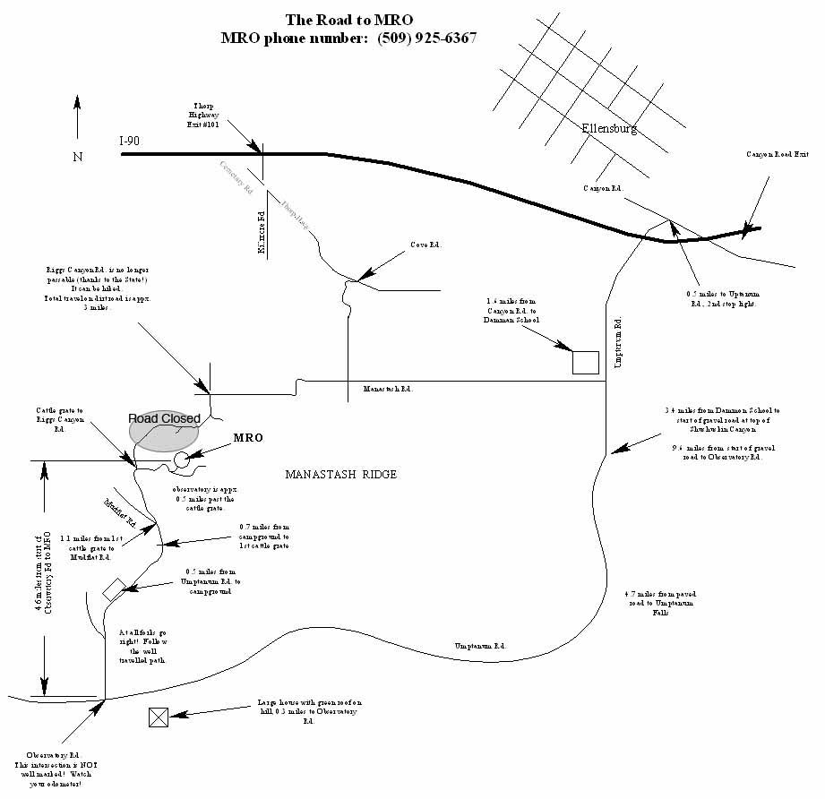
Note that Riggs Canyon Road (through Wheeler Canyon) has been closed to vehicle traffic since July 2007, but remains accessible for hiking. It is significantly shorter, steeper, and rockier than the south road. If you need to reach (or leave!) MRO on foot you should consider this route.
- Apparently mudflat road leads to “Andy Silber’s Folly”. You don’t want to go there when its wet…the name is well deserved.